Towards A Sustainable Future - A New Take on Urban Heat Mapping

Climate Change has become a real cause for concern, the evidence provided to Paris #COP21 is indisputable and wide reporting by the media, Attenborough et al are mobilising a generation. We are told we must use less fossil fuels and eat less cattle, but consumers and business have little information to make informed choices: we don’t know the carbon footprint of everyday objects let alone the footprint of companies and investments. One measure advocated by the @IEA is to use energy more efficiently and reduce our #EnergyIntensity; commercial premises alone are responsible for the vast majority of wasted energy. Notably, the enormity of the industrial and residential heat that is being produced is causing a phenomenon called the Urban Heat Island effect and the financial and environmental impact is something that businesses and organisations must be aware of and do more to tackle.
The Urban Heat Island Effect
We have all felt Urban Heat Islands (UHIs) when the city temperature is higher than the rural areas. The UHIs can be limited to a city block or extend over larger districts. The main cause of UHIs is the composition of the land surfaces and the heat emitters. Increasingly, large areas are being covered by asphalt and tarmac, and buildings are being constructed that absorb sunlight then radiate heat, thus heightening the overall temperature of the area. The surface construction, covering and even colour can have a significant influence on the contribution to the local UHI.
With nowhere for this heat to dissipate and the natural processes of evaporation and transpiration reduced due to the loss of green areas, heatwaves are more intense on UHIs. With no cooling effect, inhabitants of cities are more at risk of medical conditions such as heat exhaustion and heat stroke or even death. The UHI production can have a runaway effect in that localised hot environment requiring air conditioning to be more active and consequently producing more outdoor heat; one study reports buildings using 2.6 times more energy.
Add to this the growth of population in these areas, the use of vehicles on a large and very concentrated scale, emissions from industry and higher pollution levels, there are many factors that contribute to these UHIs. These must be addressed by the owners of the commercial premises that cause the emissions and by local authorities that hold the power to curb them, restrict energy use and other pollutants.
Left unchecked, these UHIs have direct implications. Heat accelerates pollution chemistry: high levels of toxins produced also have a very detrimental effect on people’s health and wellbeing, worsening existing health problems such as asthma and COPD. We need to locate the culprits.
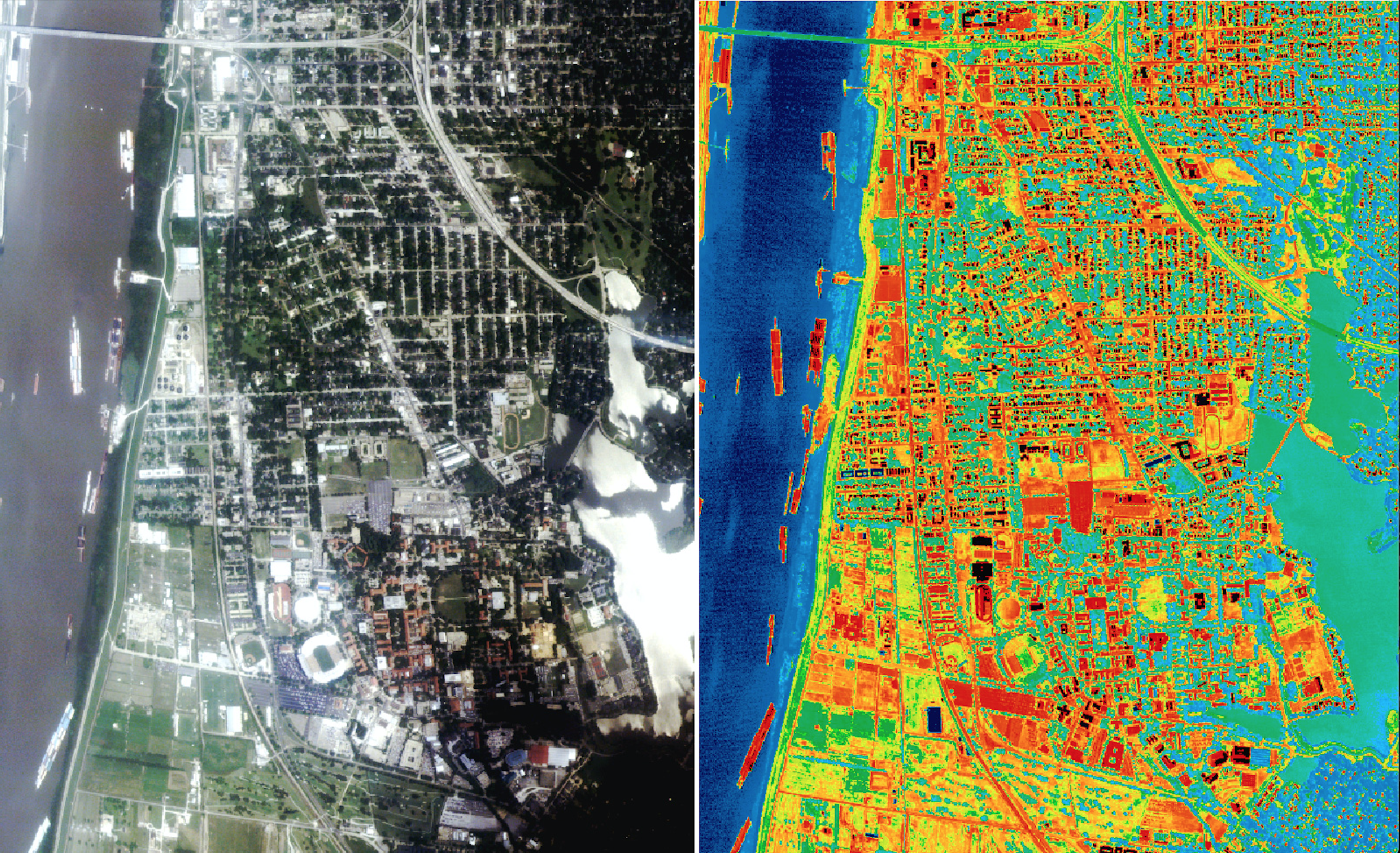
Apps are available today such as @LondonAir that can enable people to literally select the route they choose from A to B in order to avoid the most polluted streets. However, a set of altogether more detailed and highly accessible information is required.
If thermal pollution can be monitored, then measures can be taken to limit it, but, at present there is limited technology to gain in-depth understanding of where the heat is coming from to trigger these heat islands. It is nowhere near detailed, accessible or plentiful enough.
Taking Action
Satellite Vu is developing a dual-use solution that will help tackle the scourge of UHIs using high value data that will enable the commercial sector to analyse its impact on UHIs and how to mitigate it. Satellite Vu’s data can be fused with other data sources to produce computer models of smart cities often known as digital-twins.
Using innovation in satellite earth observation technology, Satellite Vu is preparing to deliver geospatial data from its commercial, high-resolution infrared-equipped small satellites. This will be processed using a unique, proprietary algorithm, creating highly accessible and actionable data enabling an extremely detailed picture of a particular site to be formed. Without the rapid and accurate interpretation of data, the imagery captured is of little use, being only a mass of Big Data. Satellite Vu’s algorithms apply both the science behind the image and the computer recognition that Artificial Intelligence (AI) can deliver.
Current satellite technology enables just one snapshot of an area per day as the satellite will typically re-visit a site just once every 24 hours around mid-morning, optical systems are restricted when urban activity can peak around twilight, yet for pattern of life analysis and dynamic unfolding events, this is simply not enough. Satellite Vu’s satellite fleet will initiate multiple visits of a site per day and fast delivery of information, essential for the time sensitive applications that Satellite Vu will be targeting. This will also improve user engagement though a responsive service, creating useful and timely insights for users. Satellite Vu’s sensor can provide information throughout the day and night and can collect data across a whole city. The solution is highly scalable to any place on earth. Satellite Vu intends to launch a satellite and sensor within the next 18 months followed by a small constellation that will improve the re-visit time.
The role of Satellite Vu in new, smart cities will also become prominent. In time, the Internet of Things is predicted to connect our cities as never before and Big Data will enable authorities and businesses to manage assets more efficiently. Satellite Vu ties in directly with this vision of the future, offering a view from space that cannot be achieved by any other means, giving insights and influencing behaviour in a completely unique way.
Satellite Vu will be first-to-market with a space-based solution that will finally offer the capabilities that the government and commercial sector require to take action on the environmental impact our modern life is making on our planet.
We look forward to making a true difference to Earth from space #earthfromspace.
CREDIT: NASA